SCRAMBLING SAFELY: Q&A WITH A PUBLIC SAFETY SPECIALIST
Words by Meghan J. Ward • Photos by Paul Zizka
Not quite hiking, not quite climbing: scrambling, as we call it, is a phenomenal way to reach summits and gain those lofty views. But while scaling certain peaks may not require ropes and harnesses, scrambling takes you into inherently dangerous terrain where a mistake could have enormous consequences. Wildly’s Editor-in-Chief checks in with Paddy Jerome (Public Safety Specialist with Alberta Environment and Parks – Kananaskis Region) for his best scrambling safety advice.

Hiking the summit ridge of Mt. Temple, one of the Rockies’ most popular scrambles due to its accessibility and height. Photo by Paul Zizka Photography.
Meghan J. Ward/ What are some common misconceptions around scrambling, in terms of safety?
Paddy Jerome/ The descriptions for scrambling routes in guidebooks are notoriously vague. Scrambling takes place in high mountain terrain that is exposed and carries inherent risks. Many of the participants have little technical rock climbing and/or mountaineering experience in terrain where harnesses, ropes and protection are typically NOT being used. The consequences of a fall in much of this terrain is usually catastrophic, resulting in some of the most horrific injuries/fatality calls that we go to.
MJW/ In your experience, what are the most common errors hikers/scramblers make that can lead them into trouble?
PJ/ Scrambling is often in very exposed 4th class (hazardous) terrain that is in exceptionally loose rock and requires excellent route-finding skills.
SCRAMBLING: 8 MOST COMMON ERRORS
1/ Errors in route-finding often lead inexperienced scramblers very quickly into technical 4th (not quite vertical, but very loose, steep and exposed alpine terrain) or even 5th class (vertical and technical rock climbing terrain), which then quickly exceeds their capacity to negotiate.
2/ Choosing trips that are not commensurate with experience level.
3/ Poorly dressed, ill-equipped (i.e. no ice axe or helmet) and/or inappropriate footwear.
4/ Starting too late in the day.
5/ Failing to factor in weather conditions (stuck in lightning storms) and route conditions for that day (i.e. new snow or icy rime on the route).
6/ Groups becoming separated. Invariably, this is one of the most common mistakes that lead to people becoming lost and/or is a precursor to an accident.
7/ No local contact. It is critical to tell someone trustworthy the who, what, where and how of your trip plan so that rescuers are able to follow up when people are overdue.
8/ Not equipped to be benighted (no headlamp or flashlight, not enough extra clothing to stay warm and no means to make a shelter).
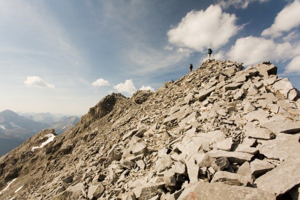
Cresting the summit ridge of Mt. Galatea. Photo by Paul Zizka Photography.
MJW/ Often people pack for a day hike and don’t think about bringing overnight gear or extra layers. Which essential items would you recommend people throw into a day pack?
PJ/ Bring these items along, even if you are heading out for only a day:
ESSENTIAL ITEMS
helmet
ice axe (if appropriate)
altimeter and topographic map
headlamp
fool proof fire-starter
light synthetic insulation jacket with a hood
light gore-tex jacket with a hood
gloves
toque
super light tarp or space blanket
good first aid kit
plenty of food and water
MJW/ Do you recommend people bring a SPOT or similar device?
PJ/ Absolutely, no question. If outside of cell range and no satellite phone is being taken in any remote location, bring a PLB (personal locater beacon), SPOT or DeLorme InReach. The DeLorme device is favoured mainly because it has two-way texting capacity which facilitates communicating specifics about the nature of the emergency and thus allows rescuers to determine urgency level and what resources would be required for the call out.

At the summit of Mt. Whymper. Photo by Paul Zizka Photography.
MJW/ Can you recommend any particular resources that scramblers should check out prior to departing on a trip?
PJ/ Topographical maps, Google Earth, scrambling guide books, SummitPost.org (online route descriptions). Online forums exist on Facebook (Scrambling in the Canadian Rockies) and can be helpful to some extent, but these folks are amateurs at best on these forums and are soliciting advice that is highly subjective. Experience levels are difficult to decipher, especially for even less experienced people seeking information.
MJW/ Anything else you’d like to add?
PJ/ It is surprising to us how few people in this day and age use and depend so much on their smartphones and don’t seem to use that same phone to call us and speak with us. We are one of the best resources available. The Public Safety Specialists here at KCPS are all certified ACMG/IFMGA Mountain Guides. We are local experts and can provide excellent advice to assist with people trip planning. Give us a call at 1.403.678.5500.
Wildly Recommended Resources:
Scrambling in the Canadian Rockies (Facebook Group)
Scrambles in the Canadian Rockies, by Alan Kane (Rocky Mountain Books)
Kananaskis Country Public Safety – Facebook Page; 1.403.678.5500
Parks Mountain Safety Facebook Page; 1.403.762-1470; website
Meghan J. Ward is a writer, editor, digital content specialist and all-around storyteller based in Banff, Canada. Meghan loves any sport that takes her up a mountain or into the backcountry, and also enjoys travel and photography.